Monte Crostis

Friuli Venezia Giulia, Italy
Monte Crostis Panoramica delle Vette
Photo © c William.Visuals shutterstock.com
For this track there are currently official closures or restrictions. Please check the comments for details.
Length
31km
Max. Height
1980m
Difficulty
Medium
Suitable for
motorcyclesuvcamper
Rating

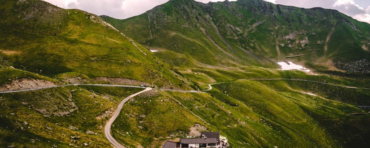
A round trip of 31 km leads over the massif of Monte Crostis through enchanting landscapes. From Comeglians on the SR 355 to Ravascletto on the SR 465.

From Comeglians we first go to the small village of Mieli and on to Tualis, where a narrow single-lane road begins. Over many narrow hairpin bends with some steep sections, this leads steadily uphill through the beautiful conifer forest. In the next part, the route meanders along mountain slopes that become more and more bare with increasing altitude and open up wide views as far as the snow-capped Alpine peaks of Austria. When reaching Monte Cortis, the narrow road turns into a well-navigable gravel road and continues downhill along the slopes towards the valley. In the last wooded section again on a small tarmac road, it is very winding through the wild mountains with many imposing peaks. On the main road SR 465 there are many inviting restaurants with typical local cuisine.


Elevation
Community-Reports (9 Reports)
D
Doreen Robert
09. Juli 2026
Date of visit:
08.07.2026
Vehicle used:
Land Rover Freelander
Closure or obstruction:
Yes

A beautiful scenic route with great views. The route was impassable from Comeglians due to paving work. However, it was passable without any problems from Ravascletto to the summit.

A
Alex Govaert
08. Juni 2026
Rating:
Date of visit:
June 2026
Vehicle used:
Land Cruiser
Closure or obstruction:
No

The trail was still closed but crowded with people over the weekend. We crossed without any problems. Fantastic views

L
Lorenz
01. Juni 2026
Rating:
Date of visit:
01.06.2026
Vehicle used:
Husqvarna 701 Enduro
Closure or obstruction:
No

A really nice trail. Pretty easy to ride and great views. A few enduro riders heading in both directions

K
Karin
16. Juni 2025
Rating:
Date of visit:
16.06.3025
Vehicle used:
Allrad Wohnmobil 3,5t
Closure or obstruction:
No

Really beautiful panoramic route. Open from Comeglians. Closed for trucks

.

H
Holly
04. Mai 2025
Rating:
Date of visit:
02.05.2025
Vehicle used:
RAM 1500 4x4
Closure or obstruction:
Yes

Road closed due to construction work just above Tualis (coming from Comeglians). Coming from Ravascletto, there is also a sign indicating that Monte Crostis is closed. However, you can drive up to it for now without any further restrictions. I had to turn back a little above Fontane Valsecca due to snow. It would have been possible to pass those spots on a motorcycle, though.

F
FrankenADVenger
20. Juli 2024
Rating:
Date of visit:
19.07.2024
Vehicle used:
R1200GS
Closure or obstruction:
No

The access road to Ravascletto is currently closed due to forestry work

M
Moritz
11. Juli 2024
Rating:
Date of visit:
11.07.2024
Vehicle used:
Tenere 700
Closure or obstruction:
No

Amazing views & great for driving.

L
Lars Lepper
16. März 2024
Rating:
Date of visit:
06/2021
Vehicle used:
Honda SD09
Closure or obstruction:
No

According to Denzel, a 4 > https://alpenrouten.de/Digola-Passo-della_point1553.html From 10/2010, Oberlandler: The trail over the Passo della Digola connects the northern approach to Forcella Lavardet (W) with the town of Sappada (E), with the pass located in the notch between Monte Terza Piccola (2,333 m) and Monte Terza Grande (2,585 m). The view from the summit southward toward the steep face of the northern foothills of Monte Terza Grande is impressive. The trail, which is partly covered in coarse gravel, is blocked by a gate (usually open) and a no-entry sign with an additional panel, but is apparently used frequently.

W
Wolle
15. März 2024
Rating:
Date of visit:
September 2022
Vehicle used:
Tenere 700
Closure or obstruction:
No

Beautiful scenery, great views, and suitable even for drivers with little off-road experience.