Col du Parpaillon

French Alps, France
Frankreich Col du Parpaillon
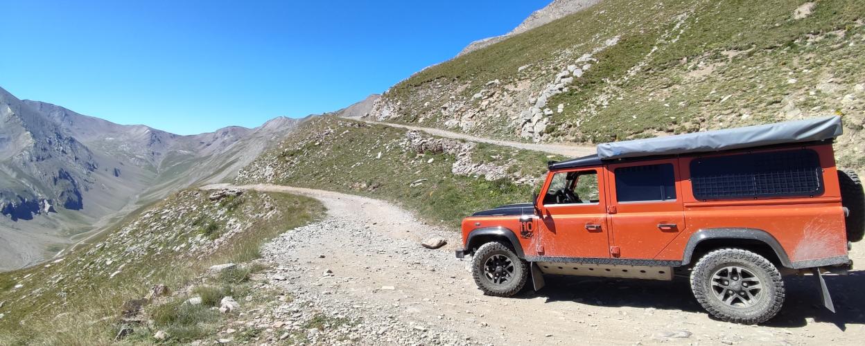
Photo © defender110roadtrip Michael Wotzko
Frankreich Col du Parpaillon
Col du Parpaillon Frankreich
Frankreich Col du Parpaillon
Length
25km
Max. Height
2632m
Difficulty
Medium
Suitable for
motorcyclesuv
Rating
Restrictions
Info: The tunnel was closed in 2024 due to partial ceiling collapses. Community Report (Sept. 2024): Although the tunnel is still officially closed, some motorcyclists have managed to pass through with their adventure bikes (as of 22.09.24). This gives hope for a possible reopening by the 2025 season.

Info: The tunnel was closed in 2024 due to partial ceiling collapses.


Community Report (Sept. 2024): Although the tunnel is still officially closed, some motorcyclists have managed to pass through with their adventure bikes (as of 22.09.24). This gives hope for a possible reopening by the 2025 season.

The Col du Parpaillon is one of the most famous gravel tracks in the French Alps — and one of the most popular. There is a good reason for this. Anyone who has made it from the 2632-meter-high pass, where the approximately 500-meter-long summit tunnel is located, back into civilization, speaks in glowing terms about the "Parpaillon experience" — for different reasons, of course.

Enduro riders and 4x4 experts can hardly wipe the grin off their faces. 

However, off-road beginners will likely have beads of sweat on their foreheads for a while. Admittedly, the Parpaillon is only partially suitable for road motorcycles and regular all-wheel-drive cars. Nevertheless, adventurers still make their way up the mountain and onto the mountain road that connects the Ubaye Valley with the Val Durance. Both ascents are challenging and are best tackled after extended dry spells. The tunnel should definitely be walked through before driving into it, as depending on the previous weather, there could be mud or even ice present.


Elevation
Community-Reports (6 Reports)
S
Stefano
01. September 2025
Date of visit:
3.8.25
Vehicle used:
Ford Ranger
Closure or obstruction:
Yes

That tunnel is definitely closed. It's been bricked up and barred!

A
Andreas Jenzer
24. Juni 2025
Date of visit:
24.6.2025
Vehicle used:
Enduro Husqvarna 701
Closure or obstruction:
No

Today we drove from south to north. We drove up from the south side (La Condamine-Châtelard) today. It was very hard. The road was partially buried/broken and there was an incredible amount of coarse gravel. The tunnel was partially collapsed and under water or treacherously icy! It was pretty borderline for me. The route was signposted with a ROUTE BARRÉE sign.


F
FrankenGrizzly
01. Juli 2025
Closure or obstruction:
No

How can you understand that the tunnel has partially collapsed?

F
Fabian
26. September 2024
Rating:
Date of visit:
22.09.24
Vehicle used:
F650 GS (20% Geländereifen und beladen)
Closure or obstruction:
No

The climb from Crevoux is a simple gravel road leading up to the tunnel, suitable even for experienced riders on street bikes. The descent after the tunnel on the other side is very rough and not suitable for pure street bikes. Extremely scenic. The descent is technically challenging (lots of large rocks on the trail); allow plenty of time here (plan for at least 3–4 hours for the entire crossing).

B
Blue Defender
11. September 2024
Rating:
Date of visit:
11.09.2024
Vehicle used:
Defender 110 TD5
Closure or obstruction:
No

Blocked with a ⛔ sign at the town limits. At Ours, there is still a sign indicating a private road and no vehicles allowed.

K
Kilian
07. September 2024
Rating:
Date of visit:
07.09.2024
Vehicle used:
Geländewagen
Closure or obstruction:
No

The road has been closed to all motor vehicles since December 11, 2023. There are several signs and barriers blocking the entrances and exits.