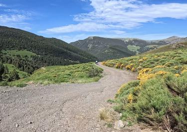
To the north of the Rio del Cantò rises a mountain massif, the highest peak of which is the 2,438-meter-high Torreta de l’Orri. It also serves as the terminus of a ski lift and the location of a radio and television station. The transmission masts, studded with antennas, on the completely bare mountain ridge can be seen from afar. It goes without saying that the panoramic view from up there is more than fantastic. The good news: a decent track winds its way from the del Cantò valley up to the Torreta de l’Orri. In addition to unadulterated off-road fun, the circuit offers plenty of great views that you won’t forget in a hurry.
The start is at an altitude of 1,650 meters on the N-260 in the small town of Rubiò. Shortly after Rubiò, the gravel surface begins. The wide track quietly follows the course of a stream that bears the same name as the town. At an altitude of 1,980 metres, the Rifugi del Rubiò comes into view, and its attractive location practically invites you to take a break.
The route has now clearly exceeded the 2,000-metre mark and swings along the left and right of a mountain ridge. It goes under the lifts of the Cota ski station to a junction. Turn left there and go up to the Torreta de l’Orri. The view is what the research promised - a panoramic view of snow-covered mountains that is unparalleled.
Back at the junction, we continue to follow the main piste and gradually make our way through a dense forest towards the valley. Finally, a handful of enjoyable bends and we reach the end point of Vilamur.


 German

 Spain