

 German

Refugi Gall
As the crow flies, less than ten kilometers west of Andorra, the small town of Alins lies in a romantic river valley. An off-road tour that is relatively easy to drive starts there, but is all the more impressive with its wonderful panoramas and cozy picnic spots.
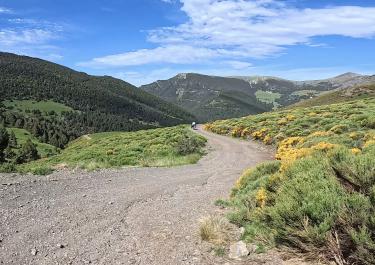
At the upper end of Alins, you first follow the signpost to the town of Noris, but then turn right after just under two kilometers onto a gravel track. Shortly afterwards, you reach the first viewpoint, the Mirador de Cassos. A short side path leads up to it.
Please note: From December 15th to June 30th, the track is closed from here. Otherwise, the route continues uphill on pleasant gravel. In between, narrow passages along the slope ensure that off-road experts don't get bored. But don't worry - the track is wide enough for larger four-wheel drive vehicles. The visual highlight is a stage that balances along a ridge and offers plenty of views.
At an altitude of 2,404 metres, the route crosses its highest point and curves downhill to the Refugi del Gall Fer. This turns out to be a real treat: the alpine house, built from natural stone, stands at an altitude of 1,690 metres and offers not only a great view but also food and overnight accommodation.
The trail continues to curve downhill, passing the hamlet of Bordes de Buiro and finally meeting the L-510 road one kilometre before Alins.
Latest reports
Conditions, closures and tips — from members who drove here recently.
Tracks Nearby
 Spain




 Spain
 Spain