

 German

Refugi de Cortals de l´Ingla
The Serra de Moixeró rises in Catalonia as part of the Pre-Pyrenees between the two rivers Segre and Saldes. Its highest peak is the Penyes Altes de Moixeró at 2,276 meters. For a long time it represented an insurmountable obstacle between the two "comarcas", a kind of district, Cerdanya and Berguedá. That is, until the Túnel del Cadí was opened on October 30, 1984, which runs under the mountain range for a length of five kilometers. Since then, around 7,000 vehicles have driven through its two-lane tunnel every year, which corresponds to a frequency of almost five vehicles per minute.
That's quite a lot for a country road in the mountains and certainly not good for the environment.
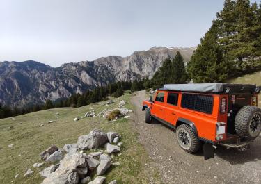
The fact that we off-roaders prefer to cross the Serra di Moixeró on a gravel track does not make us environmentalists, but it does ease our conscience. So we can fully enjoy the fun that this pleasant route brings us. From the starting point Riu de Cerdanya to the end point Bellver de Cerdanya, the surface consists of decent gravel, which the locals also drive on in normal cars. Past meadows, pastures and high alpine pastures, the route winds uphill in beautiful curves and bends, passes a hiking hut with a picnic area and finally reaches the Refugi de Cortals de l’Ingla, a stone hut for 20 people, at an altitude of 1,601 meters.
The final stage begins with a handful of downhill bends and then runs leisurely along the banks of the Riu de l’Ingla river towards Bellver de Cerdanya. “Bellver” is Catalan and means something like “Belle vue”, i.e. beautiful view.
Latest reports
Conditions, closures and tips — from members who drove here recently.
 Spain




