

 German

Tracks at Golija Massif
The Golija Massif rises in northern Montenegro, bordering Bosnia-Herzegovina, to an elevation of around 1,800 meters. The massif is deeply fissured, almost uninhabited, and virtually inaccessible by motorized vehicles. At the foot of its western flank, the Duga Valley stretches for about twenty kilometers from southeast to northwest. As a strategically important passage on an ancient caravan route, it was often fiercely contested.
As mentioned, the Golija Massif is virtually inaccessible by motorized vehicles—but only virtually. A northern off-road track skirts the mountains at mid to three-quarters height, though it doesn’t penetrate the massif itself. This route promises an adventurous journey.
The entry point is on the R7, about four kilometers north of the hamlet of Goslić. To reach it, turn northwest from the main road, the M3, near the village of Rastovac.
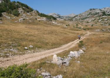
The first few kilometers of gravel are relatively straightforward and flat. Then the real challenge begins: the track transitions into switchbacks, becoming narrower, steeper, and rougher. In places, tires churn through damp earth, while elsewhere they must climb over boulders and rock steps. It’s a thrilling ride with a light enduro bike or a 4WD vehicle but can be grueling with a large or heavy vehicle.
At an elevation of 1,611 meters, the route reaches its highest point and becomes significantly tamer. On moderately coarse gravel, it winds downhill through a mix of tight and sweeping curves, passes through a few small wooded areas, and eventually meets the asphalt of the M3 at Zaborje.
Latest reports
Conditions, closures and tips — from members who drove here recently.
Tracks Nearby
 Montenegro




 Montenegro
 Montenegro