

 German

To the Ravni Plavac Plateau
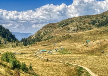
Between Kolašin, Mojkovac, Bijelo Polje, Berane, and Andrijevica lies the Bjelasica region. This mountain range, covering an area of 30 by 30 kilometers, is a volcanic formation whose highest peak, Plavac, rises 1,649 meters into the sky. Unlike most Montenegrin mountain ranges, which are composed of rugged karst rock, the volcanic Bjelasica features soft, rounded mountain shapes and gentle landscapes. It is flanked by the Tara and Lim rivers. The range is crisscrossed by several roads, which have fostered both vibrant agriculture and hiking and skiing tourism. The most scenic part of the region is the Ravni Plavac plateau, which stretches out at the foot of the mountain of the same name.
A varied and enjoyable route leads to this plateau, offering stunning views and plenty of driving fun. The starting point is on the M5 near the village of Brzava. From there, you first cross the Lim River, drive about two kilometers south, and turn onto a trail near the village of Kaludra (at 600 meters above sea level). Passing a small but noteworthy monastery dedicated to Saint Pantelimon, the trail climbs the mountain on a well-maintained gravel road until it reaches the Ravni Plavac plateau at an elevation of around 1,500 meters.
This rugged and remote piece of land is a haven for anyone seeking peace and solitude. As the trail presents only minor challenges, such as a few ruts, you can focus on the magnificent panorama of lush meadows, alpine pastures, and gray rock formations. At the end of the plateau, the descent into the Lim Valley begins – first on dirt and gravel, later on asphalt. The endpoint is Berane, the town on the banks of the Lim River.
Latest reports
Conditions, closures and tips — from members who drove here recently.
Tracks Nearby

 Montenegro


 Montenegro
 Montenegro