

 German

Picnic in Monti Gennargentu
Sprayed with silver paint in winter, painted dark green with red dots in summer - these are the colors of the Gennargentu massif. Located in the center of Sardinia, the complex mountain range stretches over a wide area. Its main valleys are called Supramonte and Flumendosa. The highest elevation and highest mountain in Sardinia is the 1,834 meter high Punta la Marmora.
There are not many roads that lead into this lonely and inhospitable mountain world. One of them begins in the town of Desulo, which can be reached via the SS 295 and SP 7 roads. Even the approach to the track is a pleasure: a dozen or so curves and bends circle up the mountainside behind Desulo. Pure driving pleasure, plenty of views. Then the track begins. It is a lot of fun to drive and covered with medium-coarse gravel. It climbs steadily uphill, overcomes a hill after about six kilometers and briefly descends into a small high valley cultivated by farmers.
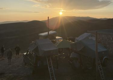
After this short run-up, the route now begins its ascent to the heights of the Monti Gennargentu. Narrow and steep, it climbs the flank of the massif in smooth curves and bends. One or two pretty picnic spots open up. But we continue and follow the signs for Punta la Marmora. This path finally brings us to the destination of this tour, a beautiful place with a great view. However, it is defended by a challenging final section with coarse gravel and stones. But it is worth it - is there a nicer place to have a picnic?
Latest reports
Conditions, closures and tips — from members who drove here recently.
 Italy




