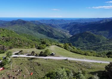
We drove the route yesterday in a VW bus… I wouldn’t recommend a much longer vehicle… At the start, there’s a nice forest road with some ruts and two spots with trees where you have to maneuver around them; no problem until the side road branches off. We didn’t take the side road because the turning area was too small and there wasn’t a good place to park. There were tire tracks visible; the route is used from time to time. After that comes a steep section that requires ground clearance and some skill with a large car in two spots. From a very nice lookout point on, it gets easier, followed by a deep muddy section…

Rocca dei Corvi
The starting point of this 5 km tour is Vado Ligure, a charming suburb of Savona along the SS1. After an initial ascent, most of the trail descends steeply.
Not far from the coastal town lies Segno, west of the highway. From there, head toward Ca’ Di Gatti. Behind the houses of this tiny village is the trail's starting point. The route begins with an uphill climb through the forest. The gravel track, marked by washouts, offers beautiful views of the coastline.
The trail continues along a ridge through a hilly section. The summit with the Rocca dei Corvi lookout tower can be reached via a short detour to the right. Located in the highlands between Vado Ligure and Quiliano, on a ridge dividing the valleys of the same names, this beautiful viewpoint offers stunning vistas. On clear days, you can see as far as Monte Rosa and Corsica.
After the detour, the route continues through denser forest, descending steeply to the endpoint in the village of Cunio. From there, return to the coast via Segno.
Latest reports
Conditions, closures and tips — from members who drove here recently.