

 German

Col Linaire La Brigue
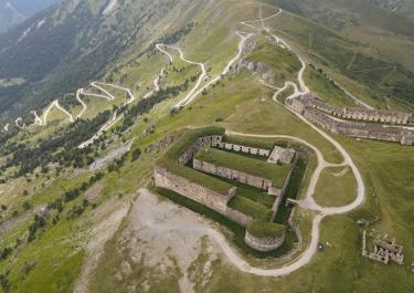
The route starting from La Brigue leads into the 4x4 and enduro paradise of the Italian-French border region via the Col Linaire, connecting to the Ligurian Border Ridge Road at the Colla di Sanson. This makes it a potential entry point for exploring the famed ridge road.
The journey begins on the northern slope of Preit, near the Notre Dame church. A no-entry sign for cars and motorcycles at the starting point was, during our last visit, turned aside and seemed to be disregarded by locals. The track to Preit is initially well-maintained but becomes more challenging after intersecting with the old southern ascent.
About two kilometers before reaching the Col de Sanson, the trail becomes smoothed out by clay soil, which can make the ride particularly tricky when wet. The upper section is exceptionally narrow, steep, and uneven, featuring numerous steps and ruts, with a steep drop-off to the side. This segment demands a strong sense of balance and a head for heights.
At the summit of the Col Linaire, the effort is rewarded with a breathtaking panoramic view. From this vantage point, you can see as far as St. Tropez and the Gulf of Genoa, and to the north, the entire region of Piedmont unfolds before you.
Latest reports
Conditions, closures and tips — from members who drove here recently.

 France



 Italy