 German
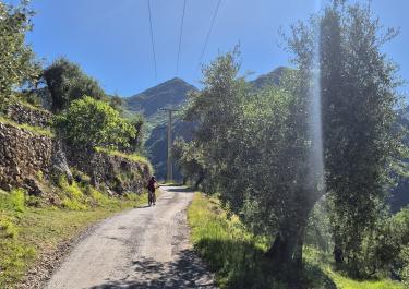
An easy trail with a great view of the surrounding mountains. There are several places to camp along the trail.
F
Felix
VW-Bus und MTB · Mai 24



The 19 km tour starts on the D 93 near the Ligurian municipality of Olivetta San Michele on the Italian border.
The starting point of the route is at the junction of the D 93 and the D 193. A small, winding road initially leads uphill, bordered by guardrails, towards Piene Haute. The idyllic village is worth a detour. From here, you have a fantastic view of the Roya Valley. The gravel road begins not far from the mountain village. Further along the road, you'll find larger stones and eroded ground. A branch leads from Col de Paula up to Mont Grazia. The path there, and also the end point on this plateau, boasts magnificent panoramic views. After the first branch, follow the route to Cime du Bosc, where a challenging detour leads uphill. Here, you'll find a statue and an antenna on the summit, surrounded by numerous rocks. An old bunker complex can be reached at the end of this branch. The final section of the tour descends through the forest. The route ends on the D 2204 at the Col de Brouis.
Conditions, closures and tips — from members who drove here recently.
An easy trail with a great view of the surrounding mountains. There are several places to camp along the trail.
An easy and very scenic drive with great views. It can be easily driven in a standard car.
The detour to Cime du Bosc (the peak with the antenna) isn’t really any more difficult either.
There are several places to spend the night along the route.
An easy and very scenic drive with great views. It can be easily driven in a standard car.
The detour to Cime du Bosc (the peak with the antenna) isn’t really any more difficult either.
There are several places to camp along the route.
 France




 Italy