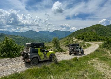
About ten kilometers south of Gramsh, there’s a track that runs from the valley of the Devoll River over a pass into the Shkumbini Valley. The pass, called Maces, stands at 1,650 meters and is relatively unknown—a common feature of many Albanian routes. So, what makes this one special? The answer lies in its challenge. This track is not for the faint-hearted, offering thrills—or terrors, depending on your skill and perspective—that will test the limits of any off-road enthusiast. Completing the approximately 76-kilometer terrain route requires serious expertise. Along the way, nearly every off-road obstacle imaginable—both beloved and dreaded—will appear: steep climbs, sharp descents, rocks, boulders, deep ruts, steps, narrow cliffside paths, mud pits, slippery surfaces, and ... well, you get the idea. Anyone not well-versed in advanced off-road techniques should steer clear.
Access to the trail is via the SH 71 from Gramsh. Between Kodovjat and Bulçar, turn left toward Kukur, and you’re off. The first stones will soon be spraying under your tires. The initial section, above a small river unnamed on maps, is relatively mild, heading east. A few hairpin turns and some coarse gravel are the only notable features. Things take a sharp turn—literally—after passing the idyllic mountain village of Kukur. The track begins to twist steeply uphill, often clinging to the edge of the mountainside. The path is narrow—sometimes very narrow—and requires steady nerves and a good head for heights.
Soon, the Maces Pass is reached, but the descent on the other side remains equally demanding. Heavy rains have eroded the track, leaving it deeply rutted—vehicles without sufficient ground clearance will almost certainly get stuck. After approximately 45 kilometers, the first houses of Bishnicë come into view, and the trail becomes noticeably less daunting. Gravel conditions return to a manageable state.
Once in the Shkumbini Valley, the route follows the river’s course. From here, it’s straightforward: a decent gravel road leads to Qeqës Shkumbin, marking the end of the journey.


 German

 Albania